case study
Natural Capital Accounting Case Study Using Satellite EO Data and the InVEST Tool
Using satellite data and ecosystem modelling to show how healthy peatlands sustain the economy, infrastructure, and our shared future.

This blog was written by members of our Geospatial Intelligence Team: Maral Bayaraa, Sarah Cheesbrough, and Daniel Wicks, and Christophe Christiaen, Head of the Spatial Finance Initiative at the Oxford Sustainable Finance Group - this piece is abridged from a longer article. View the full blog for map examples, additional information on data sets, and further context. Click here to read >>
Introduction
’I... a universe of atoms... an atom in the universe’ reflected the physicist Richard Feynman on our interconnectedness to our environment and each other. Because, ’when we try to pick out anything by itself, we find it hitched to everything else in the universe’ as the naturalist John Muir explained. In this blog post, we explore this interconnectedness through an example case study of peatland ecosystems in the North of England. We show how changes in one part of the system impacts everything else using latest data and tools from satellite Earth Observation (EO) and modelling. Moreover, we relate these potential impacts to the operations of surrounding industries, such as power plants, steel, and cement factories.
Summary of what we did and the data
One way of putting a number on the dependence of businesses on nature is the United Nations Environment Programme’s (UNEP) Nature Risk Profile. It tries to quantify the benefits and uses of nature - also dubbed, ’ecosystem services’. In short, the dependency of an asset such as a power plant on its surrounding nature is calculated based on three things, its reliance on ecosystem services, the resilience of these ecosystem services, and any risk mitigation that may be in place. This concept of quantifying the importance of nature for the operation of our industries and economy is also referred to as ’natural capital accounting’.
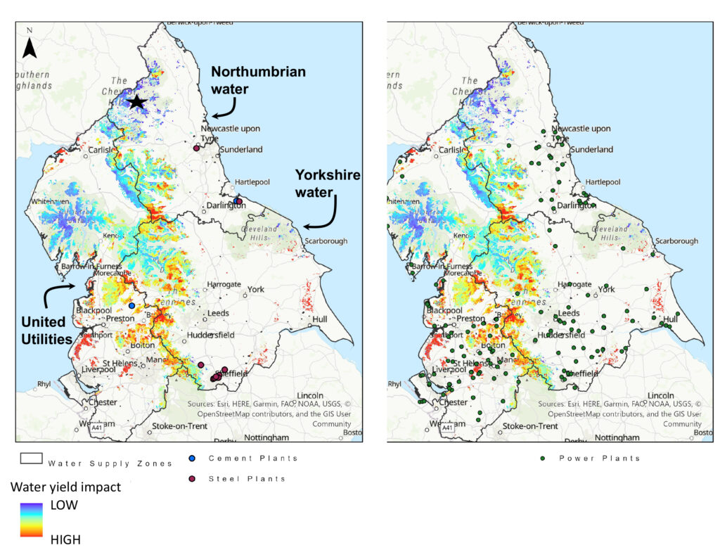
In the North of England, most of the water is supplied from surface water instead of ground water (BGS). Therefore, peatlands play a large role in providing ecosystem services related to storing and supplying fresh water in this area. In this case study, we simulate the availability of surface water (i.e. water yield) based on peatland quality and explore its potential implications for operating power plants and cement, steel factories.
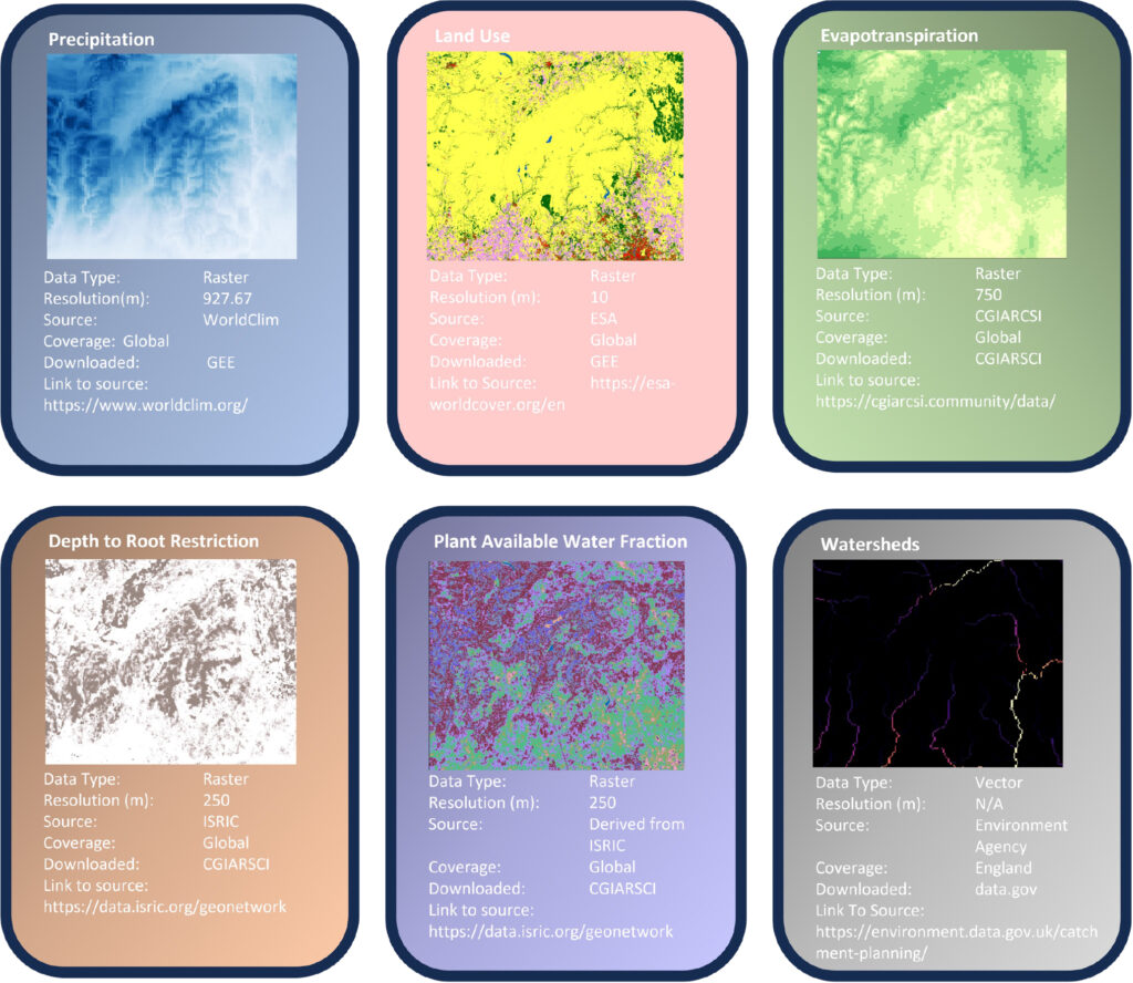
The simulation is conducted using the fantastic InVEST tool (integrated valuation of ecosystem services and trade-off). We employ the Annual Water Yield package to calculate the water yield, relying on globally available datasets outlined below. The majority of these datasets are derived from satellite EO technology. This means, they are accessible worldwide, open source and subject to regular updates, sometimes on the scale of days. Access to these data is possible through various platforms, and for our study, we utilized Google Earth Engine (GEE) as the means to access them.
Impact & Conclusion
The impact of peatland degradation on water yield varies between locations. The maps show that any peatland degradation will have the highest impact in the catchments of Yorkshire Water as well as Southern parts of United Utilities and the industries associated with those. Based on industry footprint, the operations of power plants near Liverpool will be most affected. Industries near Newcastle will be least impacted. For example, Newcastle draw their water from the Kielder reservoir, as annotated by a star. According to the modelling, this is one of the less impacted reservoirs compared to the Southern reservoirs. While steel plants in the Sheffield area seem far removed from potential water stress areas, they may still be reliant on surface water or supplied water from waterways and reservoirs that source water from peatland catchments. There are many industry and asset specific complexities that need to be taken into account when analysing and quantifying nature-related risks, but it is obvious that geospatial datasets will play a key role.
In conclusion, combining satellite and geospatial data with modelling tools such as the InVEST tool, can play an important role in understanding an asset or company’s reliance on ecosystem services, alongside the implications of degrading or improved ecosystems. The same approach can be used to assess the impact of other ecosystem services such as carbon or soil/sediment retention. This would then allow a comparison of the impacts on different types of ecosystem services and decisions can finally be made on real up-to-date data. By using frameworks such as those from TNFD and UNEP, these can then be translated into financial implications, which will ultimately make an economic case for restoring and maintaining healthy ecosystems such as peatlands, so that our economy and future generations can continue benefiting from the many services nature has to offer. There is huge impact to be realised immediately, right now, if practitioners and users can start to adopt today. At the Satellite Applications Catapult, we want to help reduce the barriers to this adoption and help push towards the sustainability goals. If you are a researcher, a user, or a practitioner in this topic, we want to collaborate with you. Please do reach out to us.
More case studies

The Space Commercialisation Engine: Facilitating the use of EO Data
Context The Space Commercialisation Engine (SCE) was designed to leverage Earth Observation (EO) data for business innovation. It aims to…
