Over the past year, Riskaware have – through contracts with the Satellite Applications Catapult – provided key modelling support to the UK’s Department for International Development (DFID) by performing investigations into the risks posed by the FSO SAFER oil tanker.
Situated off Yemen’s west coast in the Red Sea, the SAFER is a floating oil terminal with a current cargo of over one million barrels of oil. Since the outbreak of the Yemeni civil war in 2015, the SAFER has fallen into a state of disrepair, and there are concerns in the international community that the vessel is at risk of releasing its cargo into the environment, either from a leak from the vessel itself or an explosion/fire on board leading to the release of particulate pollution. Such a release would have a catastrophic impact on the vulnerable ecosystems and infrastructure surrounding the SAFER as well as local populations, many of whom rely on the waters of the Red Sea for their livelihoods.
Riskaware were asked to apply their expertise in the use of modelling tools and techniques to produce predictions of the potential impacts of a release of air- and water-borne pollution from the SAFER, in order to better inform the international discussion surrounding the fate of the tanker and the risks it poses to the region.
On 8 July 2020 the US Secretary of State, Mike Pompeo, gave a briefing during which he included the Catapult and Riskaware’s analysis of SAFER, including imagery produced as part of our activity. Follow the link below to watch:
https://youtu.be/epG3ZW02lsY?t=997
The Riskaware team brought together our capabilities in both atmospheric and oil spill dispersion modelling to bear on this urgent problem. Applying a statistical approach, we used NOAA’s HYSPLIT model and our own MarineAware platform to analyse thousands of individual model runs to estimate the regions most likely to be at risk of high levels of contamination at different times of year.
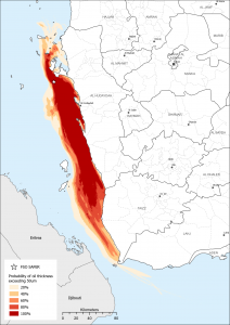
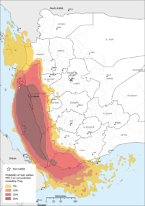
Some of the outputs generated from Riskaware’s oil spill and atmospheric dispersion modelling, showing predictions of the areas most at risk of contamination for a release occurring between July and September.
The SAFER is in an exceptionally high-risk location, with vulnerable coral reefs and important fishing areas, ports and desalination plants located in the area. The region also contains key shipping routes, with over 20,000 ships passing through the Bab-el-Mandeb Strait each year; this further increases the potential damage and cost caused by an incident.
The results of these modelling campaigns have been used by DFID to feed into the international conversation surrounding the vessel, with the results being disseminated internationally at the highest levels “We consider ourselves very privileged to have been asked to work on this project”, Murray Purves, a consultant at Riskaware says. “We aim to apply our experience with incident modelling in a way that can hopefully help to bring about a positive outcome in a complex situation.”
With the potential for such diverse, far-reaching and severe consequences, Riskaware’s incident modelling tools can offer valuable assistance to authorities, providing actionable intelligence that can be used to affect positive change.
