What is hyperspectral imagery?
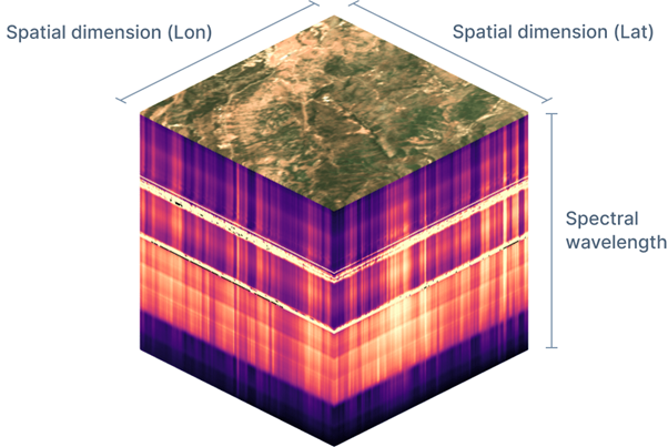
Hyperspectral imaging is a process of obtaining high spectral resolution imagery by dividing it into many narrow, contiguous spectral bands across the electromagnetic spectrum, typically in visible and infrared wavelengths (eoPortal, 2025). A hyperspectral image is composed of a series of individual images, each one corresponding to a specific spectral band. This collection of images is represented as a spectral cube (Figure 1), featuring two spatial dimensions and one spectral dimension, allowing for detailed analysis of the materials and features within the captured scene.
5 key things to know about hyperspectral
Having more bands creates opportunities – the small gap between bands is key
Hyperspectral data is characterised by many spectral bands, but what distinguishes it from other types of imagery is near-contiguous spectrum with only narrow gaps between the bands. This means the spectral fingerprint (or signature) of an object can be determined, which can be used to distinguish between two objects which are a similar colour (species identification), as well as tiny differences between the same thing (such as unhealthy crops).
There is the ability to ‘Pick and Choose’ based on use case
Hyperspectral satellite companies have started to provide the ability to ‘pick and choose’ the bands required for each use case (Pixxel, 2025). Selecting only the bands required can reduce some of the challenges associated with hyperspectral imagery, such as the amount of storage required. Depending on the use case, there are key indicators which can be identified from hyperspectral imagery. For example, to measure water quality, one indicator is Chlorophyll-a, which is best identified from 450-705 nanometres (nm) and 761-891 nm.
Hyperspectral imagery pre-processing methods tend to be specific to each sensor
When hyperspectral imagery is acquired, it tends to require multiple stages of processing before being ready to be used. Each sensor is different, bringing various requirements for pre-processing and correction algorithms. For existing satellites, such as European Space Agency’s Sentinel-2, there has been substantial research into processing, producing standardised approaches. This is not yet the case for hyperspectral imagery. As more satellites are launched, it is likely these approaches will become simpler.
Extra noise requires extra processing
Having a high spectral resolution produces extra noise through information in bands close to each other being repetitive. The substantial data volume this resolution produces leads to storage and computational power issues. There are methods, such as dimensionality reduction, which can remove unnecessary noise. These methods are rarely required when using multispectral imagery.
There is significant potential from commercial hyperspectral satellite imagery
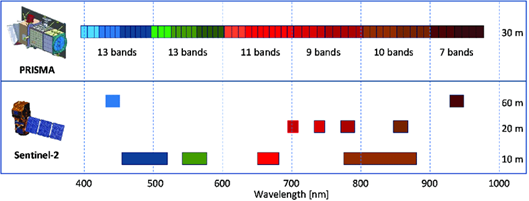
Currently, the focus in research is mainly on open-source hyperspectral satellite imagery and commercial drone hyperspectral imagery. Drone data can measure and monitor small features due its high spatial resolution. The scale it can operate is limited, often it is an area the size of a housing development being captured. The spatial resolution of hyperspectral satellite imagery has been a challenge for these applications. This is due to change imminently. Pixxel’s Firefly constellation, launched early 2025, aims to achieve 5-metre spatial resolution. Planet’s Tanager satellite, although the same spatial resolution as ESA’s PRISMA (30 metres), has an increased spectral resolution of 5nm compared to 12nm. These improvements have significant potential, as the data should be applicable to more use cases.
Find out more
It is an exciting time to be using hyperspectral imagery. At the Satellite Applications Catapult, we work with organisations to find the right Earth observation solutions for their needs. If you are exploring hyperspectral options, reach out and we would be happy to support you.
This blog was produced by:
- Isabelle Crozier-Morris, Senior Earth Observation Consultant
- Liz Scott, Geospatial Solutions Architect
- Jean Joy, Earth Observation Consultant
References
Element84, 2025. Hyperspectral satellite imagery for Earth Observation. [Online]
Available at: https://element84.com/demos/hyperspectral
[Accessed 25 JUL 2025].
eoPortal, 2025. Hyperspectral Imaging. [Online]
Available at: https://www.eoportal.org/other-space-activities/hyperspectral-imaging
[Accessed 13 May 2025].
Niroumand-Jadidi, M., Bovolo, F. & Bruzzone, L., 2020. Water Quality Retrieval from PRISMA Hyperspectral Images: First Experience in a Turbid Lake and Comparison with Sentinel-2. Remote
Sensing, 12(23), p. 3984.
Pixxel, 2025. Bandsets: Use cases. [Online]
Available at: https://support.pixxel.space/hc/en-us/articles/20311517019548-Bandsets-Use-cases
[Accessed 22 JUL 2025].
