“Working with the Satellite Applications Catapult has enabled Environment Systems to access new markets that align with our strategic goals. The projects and services we have delivered have each led to other opportunities in Latin America and the Caribbean. This has enabled us to grow Environment Systems commercially whilst at the same time developing new skills and capabilities that ultimately benefit all our customers.”
Steve Keyworth, Co-founder and Director
Environment Systems is an environmental and agricultural data consultancy that has provided trusted evidence and insight to Governments and industry across the world since 2003. Their consultancy services deliver bespoke advice and solutions for land management, monitoring and policy for ecosystems, agricultural trials and agricultural supply chains.
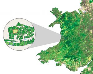
SENCE (Spatial Evidence for Natural Capital Evaluation) Environment Systems’ natural capital tool provides place-based information on natural capital to identify where there are opportunities to enhance natural capital in the landscape. It provides scientifically robust evidence to show:
- Where the environment is working well – for example areas of woodland helping to prevent soil erosion, slowing rainfall thereby helping to reduce flood risk and storing carbon whilst also contributing to landscape character.
- How we can use the environment to avoid serious issues – showing where there are risks to land, for example by identifying land susceptible to soil erosion, flood or coastal retreat.
- Where the best places are to site new activity and developments – working with local stakeholders to identify key risks on the ground and engage them in designing appropriate solutions such as planting schemes.
Environment Systems Data Services delivers accessible Earth observation insights and analytics using Sentinel data from European Space Agency servers which is then processed in the Cloud, with multiple indices and radar data enabling users to select only the data they actually need.
Environment Systems has worked with the Satellite Applications Catapult for a number of years. In 2016 it was involved in the IFSAC (Improving Food Security and Agricultural Competitiveness in Peru) project which was brokered by the British Embassy in Peru and project managed by the Catapult. Find out more on our Projects Hub.
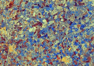
The objective was to identify differences in crop vigour as well as to understand and map the effects of pests and disease in grapes in the Piura region. Ultimately the project established that regularly updated crop level insights can be used to help drive agricultural performance. We connected with growers across the region to understand their needs and then used SAR (Radar) backscatter data from Sentinel-1 and NDVI indices derived from Sentinel-2 data to develop the evidence base and demonstrate the ability to monitor the grape crop.
The experience gained on that project made Environment Systems the natural choice to lead one of the UK Space Agency’s IPP (International Partnership Programme) projects in Latin America. This project, ‘EO4cultivar,’ is increasing the resilience and sustainability of commercial agricultural supply chains operating between Colombia, Peru, Paraguay and the UK.
The project delivers new forms of evidence and advice to growers, farm advisers, and other stakeholders ultimately helping adapt farming practices in response to new knowledge derived from Earth observation. EO4cultivar has developed Agri-track which offers a suite of crop monitoring and forecasting products at farm, regional and national scales building on Environment Systems’ world class capability in Earth observation analytics.
Environment Systems was involved in another project managed by the Catapult in 2020. A discussion between the Catapult and the Inter-American Development Bank (IDB) explored opportunities for satellite data to enhance IDB projects. One identified project was to provide an assessment of agricultural production in Venezuela, required due to the severe economic, humanitarian and political crisis over the past decade. The Catapult has highlighted the leading capabilities of UK industry to deliver on the proposed project, contracting the project to Environment Systems.
On this project it was able to demonstrate scalable and repeatable mapping solutions which used both moderate and high-resolution satellite data to establish the current status of agricultural activity (2019) including active and inactive fields in cropland areas and classified by crop type.
To find out more about Environment Systems, visit their website.
More resources from Environment Systems: