On 28 November, the Satellite Applications Catapult, European Space Agency, and United Nations Crime Institute (UNICRI) hosted a workshop to discover how space-enabled applications could support the mining industry. During the workshop key businesses from the Space Industry showcased the potential of space technologies. We have addressed variety of challenges mining industry facing and discussed how space technology can provide solutions. Please see below in more detail what was discussed during the day.
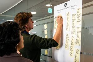
MONITORING AND IMPROVING MINING OPERATIONS
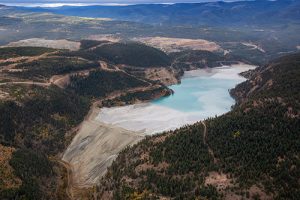
Satellite capabilities, combined with additional datasets, can create great value for monitoring and improving operations throughout the mine lifecycle. During the exploration phase, satellite data can offer insights on surface deformation, mineral alteration, heath flow, and vegetation anomalies, identifying specific areas for detailed exploration and informing planning for drilling boreholes. Furthermore, optical imagery and digital elevation models can support bathymetric measurements for water depth on tailings dams, monitoring of specific areas such as the tailings dam’s freeboard, and provide detailed information on heights and slopes. InSAR data can help to spot potential issues, by monitoring ongoing ground deformation and displacement.
Satellite data can assist decision making for traders, brokers, analysts, and producers, through monitoring assets using both still imagery and video from space. Furthermore, it is possible to assess the depth of pits and observe extraction using digital surface models, and monitor ore volume changes through 3D change detection. Satellite communication can provide real-time data in remote locations. This can provide connectivity across mines, allowing sensors (field instruments) to be connected to the internet (internet of things) facilitating real-time information streams. This capability spans across the whole mining lifecycle, from exploration (supporting connectivity in the field), to production (through automated equipment), to closure (with remote automated monitoring).
From the investors’ perspective, there is a growing need to clearly understand which mining companies are not operating best practices and could pose a risk to their investments. Satellite data can help verify companies’ compliance with environmental policies on deforestation, emissions, climate change resilience. There is currently not much information available on closed or abandoned mining and tailings facilities or, importantly, their impact on the surrounding environment. This is particularly relevant when considering the absolute number and location of many tailings dams globally is unknown, and therefore difficult to quantify in terms of risk. There is an opportunity to support the identification of dams through satellite imagery and help the quantification of risk.
FACILITATING SOCIAL ENGAGEMENT IN MINING
Timely and relevant information is vital for the wellbeing of communities that live around the mining area. Their priorities include access to clean water sources, monitoring of air pollution, the environmental impact of mining activities and transparent information about the risk they are exposed to. Communities require a clear explanation of how the site is going to evolve throughout the lifecycle and want to be able to feedback and report on mining operations effectively. In case of incidents, it is important for the mining companies to understand the impact and manage remediation and complaints in a timely manner. Communities need to have clear information on how the situation is going to be tackled and restored, and what the impact will be on their daily activities. Satellite imagery offers the opportunity of facilitating these conversations through visual evidence. It can provide local communities with insights on how their area is changing over time as well as visualising the predicted growth of the mining site in the future. Equally, it can support social engagement in case of incidents, showing the remediation efforts put into place over time and their actual effectiveness.
It is important for mining companies to understand the sovereignty of indigenous communities over specific resources and areas of interest. Some communities might not be officially classified as indigenous, but they might have been living in the area for generations. It is key to have access to a detailed baseline analysis of the area around the mining site, as well as understanding the impact that operations will have on the environment, local mining, immigration, and social structures. Satellite applications can support baseline mapping, identification of communities, infrastructure, and other relevant geographical features – and show how they change through time. If community relocation is needed, satellite imagery can support the scoping of alternative sites. Satellite applications can also support the mining companies in understanding opportunities for strategic investment into the area, in order for them to support the local ecosystem by stimulating socio-economic development opportunities.
SAFETY AND SECURITY OF THE MINING SUPPLY CHAIN
Illegal mining and the illicit trafficking of precious metals is a growing phenomenon. Often controlled by transnational organised crime groups, it involves illegal miners operating in dangerous conditions, like abandoned mines. There is a need to strengthen the mining supply chain against theft at source, illegal smelting, and national and international illegal buying, monitoring legal mining activity, as well as tracking legitimate goods remotely. Artisanal mining sites are often remote and dangerous to access and are hence often hard to identify and monitor. Unrecorded mining activities, even in urbanised areas, can affect ground movement. Satellite applications can help identify artisanal and small-scale mining sites, through observation of the changes in the surrounding environment and proxies like land subsidence or human movement.
Satellite applications enable observation of logistic activities (through proxies such as moving cranes, vessels in harbour, stockpiles) as well as classifying and monitoring volume capacity changes in stockpiles, enabling monitoring of legal mining activity and tracking of legitimate goods. Satellite communication underpins safety and security on-site, supporting connectivity and information exchange. It also enables the running of specific applications that relate to safety on-site, such as fatigue detection and management systems.
ENVIRONMENTAL MONITORING OF MINING SITES
There is a pressing need to protect Earth’s environmental ecosystems while ensuring access to stable employment and economic growth. The use of satellite data is a critical tool to provide meaningful and qualitative information looking back and over time; it can be used to create an environmental baseline and feed into an Environmental Impact Assessment (EIA). Mining companies are also faced with multiple challenges when it comes to the ecological restoration of mining areas. The current restoration techniques are not as advanced as other mining operations, and the processes are often very complex (for instance, it is important to understand the distribution and location of specific plant species). Access to environmental data is key throughout the mining lifecycle. For instance, ground stability data (land subsidence, infrastructure movements), as well as slope analysis, can offer information on the condition of the soil and potential risk of erosion. Optical imagery can provide information on leaching, as well as monitoring the presence and health of the vegetation. Integration with other datasets can help identify trends and changes over time, and machine learning can support the automation of these processes.
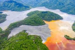
Water is a fundamental resource to monitor over the whole duration of the mining lifecycle. In case of an incident, it is important to timely understand the extent of pollution and contamination in the water bodies surrounding the site. Mining companies need to ensure that local communities have access to required amounts of clean water for them and the sustaining of their livelihoods (agriculture, farming). Analysis of satellite imagery, combined with groundwater data, offers the opportunity to provide intelligence on water quantity and water quality parameters.
Mining operations also require a considerable amount of energy, and they are often located off the grid. There is an opportunity for satellite applications to support the identification of renewable sources of energy.
At the end of the Workshop we launched special interest group – MineSense as a platform for stakeholders of the mining and space industries to collaborate and discuss new technologies, opportunities, and solutions to solve challenges of mining industry using space technology. You can join MineSense group here.
