
Governments and businesses around the world have made significant commitments to reducing emissions in the race to Net Zero by 2050. Industrial processes create a sizeable chunk of those emissions that we need to collectively reduce.
Satellite data and remote sensing can be used to effectively monitor, track, and verify emission levels both directly and indirectly. This will enable us to understand the position we are in now and the progress we are making on this journey.
To hold companies and governments to account, attribution of emissions to their actual sources is key. Asset-level data that links industrial assets to their location and ownership is a prerequisite for satellite data to be used effectively for reducing emissions in the most intensive of industries. The Satellite Applications Catapult’s work on open global asset-level databases for heavy industry provides the foundations for a wide range of new applications in this area.
Industrial sectors are a significant source of greenhouse gas emissions
Industrial processes around the world are a significant source of greenhouse gas emissions. Energy use within industrial sectors such as iron and steel, chemicals or car manufacturing accounted for 24.2% of global greenhouse gas emissions in 2016. Whereas emissions from direct industrial processes, such as CO2 released when producing cement or ammonia, added another 5.2% of global greenhouse gas emissions[1].
Many of these industries create products and materials that are essential for our economy, including for the climate transition. But they use energy intensive processes that are notoriously hard to decarbonise. Each industry has its own unique decarbonisation challenges and is exploring different ways to green up their act. For instance, replacing coal in the steelmaking process with (green) hydrogen, or shifting from fossil fuel to biomass-based feedstocks for chemical processes.
Nonetheless we need to reduce industrial emissions fast if we are to live up to commitments, we have collectively made in the Paris Agreement. Satellite technologies can play an important role in facilitating decarbonisation policies and investments. Alongside holding industry, regulators or even governments to account when it comes to progress against net zero commitments.
Satellite technology for independent monitoring, reporting and verification
Satellite technology provides practical and scalable solutions for monitoring, reporting and verification of industrial greenhouse gas emissions, as it provides:
- An objective source of information collected by third party operators, available to industrial companies, investors, or civil society organisations alike.
- A scalable and comparable source of information that can be collected across large numbers of assets, without having to set a foot on site; and
- A timely source of information with data points that can be collected
Advances in both satellite hardware and data processing technologies make it possible to observe greenhouse gas emissions either directly or indirectly. For instance, GHGSat’s fleet of satellites is capable of monitoring methane concentrations at a spatial resolution of 25 meter. Allowing direct methane emission observations to be attributed to individual assets such as oil & gas infrastructure, coal mines or landfills. Emissions can also be estimated indirectly by combining time series of optical and other passive satellite sensors with asset-specific information, as outlined in TransitionZero’s Turning the Supertanker report. By assessing how often a power or industrial plant is operating and knowing the plant’s fuel type (e.g., coal), capacity, age, etc. they can model emissions at the asset-level and derive analytics for policymakers and investors.
Some of these methodologies are now being applied on a global scale, to create transparent and open greenhouse gas datasets for the most emission intensive industries. ClimateTrace is a coalition of innovative tech companies that use satellite imagery and artificial intelligence to create open emissions inventories across sectors such as power generation, manufacturing, forestry, and land use sectors and more.
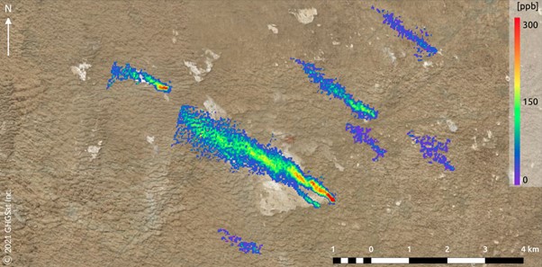
An image captured by a GHGSat satellite shows at least eight separate methane leaks in central Turkmenistan on February 1, 2021. Source: GHGSat Inc., Bloomberg
Asset-level data as an enabler for climate action
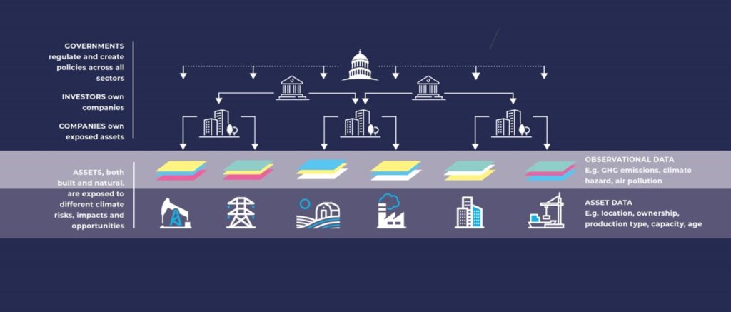
For satellite data to be used effectively in monitoring net zero progress, observations need to be attributed to the exact emission sources or assets and the companies that own them. Asset-level data that ties physical assets and their exact location, to ownership, is a crucial to link geospatial and observed datasets with actors on the ground and their owners, investors, or public institutions.
This allows emissions data from individual assets to be aggregated at the company, portfolio, regional, or global level to hold the different stakeholders across the value chain to account against net zero or other commitments. For instance the ‘green recovery’, ‘just transition’ and ‘levelling up’ agendas or reducing biodiversity loss as outlined by the G7 Finance Ministers and Central Bank Governors Communiqué at the G7 Summit in Cornwall earlier this year.
Source: Spatial Finance Initiative, State and Trends of Spatial Finance 2021
Through Catapult’s involvement in the Spatial Finance Initiative, we aim to increase access to asset-level data tied to ownership across all major sectors and geographies. Within our asset-level data project, we created open global asset-level databases for the cement and steel industry. Using a combination of manual and machine learning techniques to analyse satellite, geospatial and web-based datasets, we managed to identify cement and steel plants and their key characteristics. This was then matched to ownership based on public disclosures and databases, and centralised in global asset inventories that are openly available to support a wide range of use cases.
The UK space sector has a lot to offer in the fight against climate change and the race to net zero, but we need to make our data more actionable, and we need to do it fast. By getting it in the hands of decisionmakers and influencers across government, investors, civil society, in a format that they can understand and work with.
COP26 offers the momentum and global stage we need and there’s never been a better time to do so. Now is the time to step up to the challenge.
