Contributors: Electra Panagoulia, Sarah Cheesbrough, and Cristian Rossi.
At the start of lockdown earlier this year due to the COVID-19 pandemic, scenes of long queues and empty shelves in supermarkets were commonplace. Food supply chains experienced unprecedented stress due to the extreme increase in demand; compounded by the fact that people were unable or not allowed to travel. Never has it been more important to monitor agricultural production on a regular basis, anywhere in the world, in order to predict food production and thus accurately coordinate subsequent processes in the food supply chain to balance supply and demand. Restrictions on national and international travel have meant that, where possible, remotely monitoring food production is preferable; this is also more sustainable in terms of cost.
These requirements and challenges make satellites particularly well-suited to the agricultural domain, including the use of Earth Observation (EO) imagery which consists of the acquisition of weather, optical, or SAR data, all of which can assist decision making in food production. Satellites can monitor vast swathes of land globally, on a regular basis, and provide actionable information with little or no human intervention.
The potential of satellites has attracted increasing amounts of attention from stakeholders across food supply chains over the last decade, resulting in an increasing number of applications and services based on satellite technology, many of which take advantage of EO imagery. These services and applications range from enabling real-time data collection from farms through the use of satellite communications, to predicting yields and optimised harvest periods to determining the relative health of plants in a field so this can be used as an input for variable rate agrochemical application. To learn more about the services that satellites can offer in agriculture, please read the Satellites in Agriculture report that the Satellite Applications Catapult created in collaboration with the Agriculture and Horticulture Development Board (AHDB).
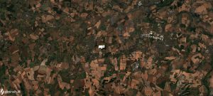
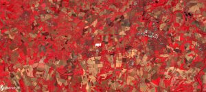
Sentinel 2 images taken over the Harwell area. 12 August 2020.
- The top image is a true-colour composite (i.e. what you would see with the naked eye),
- The bottom image is a Near Infrared false colour composite, to highlight the healthier vegetation – red indicates healthy vegetation.
The Satellite Applications Catapult is committed to removing barriers to the access and use of EO imagery in all sectors, including agriculture, and the Geospatial Intelligence (GI) department has been key in helping achieve this. The GI department has two main purposes:
- To be recognised as one of the UK’s leading independent geospatial technologies innovation teams, enabling UK businesses to benefit from the power of geospatial data and associated computing technologies.
- To deliver geospatial data and technologies expertise, knowledge, and capability, through commercial, collaborative, and R&D projects that enable demonstrable impact through the growth and development of UK geospatial businesses.
GI comprises individuals with a wide variety of expertise, from EO imagery analysis to machine learning, to geospatial information systems (GIS), to software engineering and front-end design, allowing the creation, development, and deployment of viable and sustainable end-to-end solutions. The team has experience working on agricultural projects spanning the globe, from Australia to Latin America, as well as closer to home in the UK, and so are familiar with delivering solutions that meet a range of user requirements and technical challenges.
This experience and expertise combined with the Catapult’s Neutral Trusted Entity (NTE) status, enables the GI department to make an impartial assessment to ascertain the most suitable technology for a commercially sustainable solution. The NTE status encourages the Catapult to operated alongside subject matter experts from academia, industry, and government to support solution delivery, enabling appropriate collaborations. Finally, the GI department is involved in national and international committees/working groups on geospatial data, services/applications, and software engineering, and is therefore well aware of national and international developments on a range of geospatial topics.
Overall, the GI department is committed to delivering sustainability and innovation in technological solutions for the agricultural sector around the world, bringing a wealth of expertise and experience to the adoption of geospatial solutions within agriculture.
Subsequent blog posts will be published on the use of multispectral and Synthetic Aperture Radar (SAR) data and GIS in agriculture in the following months. Please visit our website or follow our social media channels to learn more!
If you wish to learn more about the Catapult’s work in agriculture, please contact the Head of Agriculture, Mark Jarman (mark.jarman@sa.catapult.org.uk), or visit our website: https://sa.catapult.org.uk/markets/agriculture/.
If you are interested in learning more about the Catapult’s work in Geospatial Intelligence, please contact the Director of Geospatial Intelligence, Peter Beaumont (peter.beaumont@sa.catapult.org.uk), or visit our website: https://sa.catapult.org.uk/markets/geospatial-intelligence/.
