Copernicus Masters Finalist: TRACE – Tool for Recording and Assessing the City Environment
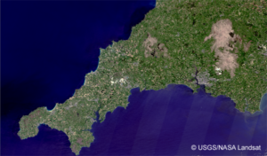
Eloise Marais is an Associate Professor in Earth Observations at University of Leicester and is one of our three finalists in our Copernicus Masters Data...
Eloise Marais is an Associate Professor in Earth Observations at University of Leicester and is one of our three finalists in our Copernicus Masters Data...
Daniel O’Connell and Jeremy Gondolf are the founders of WindAI, one of our three finalists in our Copernicus Masters Data Visualisation Challenge. WindAI is a...
The Satellite Applications Catapult is delighted to announce its partnership with Frontier Development Lab (FDL) Europe, an AI research accelerator solving worldwide challenges using satellite...
The Copernicus Masters is an international competition that awards prizes to innovative solutions, developments and ideas for industry and society based on Earth Observation (EO)...
Catapult Co-Author: Crisitian Rossi This paper presents a nonlocal InSAR filter with the goal of generating digital elevation models of higher resolution and accuracy from...
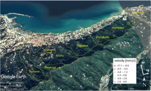
Catapult Co-Authors: Esra Erten, Cristian Rossi & Terri Freemantle Rize, a city with about a hundred thousand inhabitants on the Black Sea coast in the north-east...
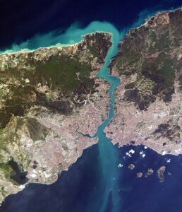
Catapult Co-Author: Esra Erten & Cristian Rossi Turkey, as a developing country, is designing and performing huge construction projects around Istanbul, now that it is the...
Catapult Co-Authors: Daniel Wicks, Thomas Jones, Cristian Rossi To access the valuable information contained within Earth observation data, users are required to undertake a series of...
Catapult Co-Authors: Cristian Rossi, Maral Bayaraa, Stephen Spittle, Anoop Pandey, Niki Henry This paper presents an overview of a large research project involving collaboration from the...
Catapult Co-Authors: Maral Bayaraa, Stephen Spittle, Chris Williams, Vladimir Stoiljkovic Tailings dams risk reduction is one of the highest priorities within the mining industry and presents...
Catapult Co-Author: Cristian Rossi Topographical information is of major interest when assessing material flows throughout active volcanic systems. In order to obtain accurate estimates of...
Catapult Co-Authors: Cristian Rossi, Maral Bayaraa, Stephen Spittle, Anoop Pandey, Niki Henry The increasing global effort to overcome the addiction to fossil fuels is driving the...