Catapults driving engagement with SMEs
SMEs from across multiple industries are being encouraged to attend a special cross-Catapult event designed to help businesses turn their ideas into commercial ventures. The...
SMEs from across multiple industries are being encouraged to attend a special cross-Catapult event designed to help businesses turn their ideas into commercial ventures. The...

The Satellite Applications Catapult, an independent technology and innovation company, has led a cross-industry workshop on the “Role of Satellites in Operational Situational Awareness”. Hosted...
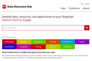
The Satellite Applications Catapult, an independent technology and innovation company, has joined with the UK Space Agency to provide an accessible ‘Data Hub’ that makes...
Intelligent Precision Farming wins UK leg of European Satellite Navigation Competition An innovative new mobile app for farmers able to pinpoint and identify disease, pests...

The Satellite Applications Catapult, an independent technology and innovation company, last night presented the winner of the Copernicus Masters Transport and Logistics Challenge, Stevenson Astrosat...
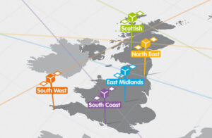
The Satellite Applications Catapult, an independent technology and innovation company, is working with the North East Satellite Applications Centre of Excellence and Satellite Finance Network...
By Stuart Martin, CEO, Satellite Applications Catapult Since taking up my role at the Satellite Applications Catapult, I have been asked many times to talk...

Spaceport UK will be a pillar of growth for the UK and European space industry, enabling lower cost access to space, and creating economic benefit far...

The Satellite Applications Catapult, an independent innovation and technology company, is getting ready to operate one of the UK’s latest national satellites, TechDemoSat-1. It will...

Every time you buy seafood at a restaurant, store, or waterfront dock there is a 1-in-5 chance that the fish was caught outside the law....
Weather Safe Ltd, a start-up company based in the Harwell Space Cluster, was very honoured to be invited to a Reception for UK Technology Industry...

Satellite Applications Catapult CFO/COO, Antonia Jenkinson The Satellite Applications Catapult, an independent innovation and technology company, has committed itself to the Government’s ‘Your Life’ initiative,...